18 days Round Manaslu Trekking
Popular
Round Manaslu trekking is inspiring for many trekkers due to the amazing landscape, and culture of native people. A decade back Manaslu Trekking was not popular trekking in Nepal due to poor recognition. But, in recent years Round Manaslu trekking is attracting the trekkers of Annapurna Round trekking.
The Round Manaslu trekking trail follows ancient salt trading route alongside the Budhi Gandaki river in the tropical climatic zone. You can enjoy the subtropical evergreen-deciduous forest around Jagat and Deng. Pine, spruce, oak, and rhododendron forest are the main vegetation on upper and lower temperate region, especially around Gap, Namrung, and Lho.
The trekking continues to the alpine habitat of Samagaon and Samdo and finally snowline once you are at Dharmashala and Larkey La pass (5106m). The alpine region mostly has open meadows with small juniper bushes while snowline is icy and rocky. The Round Manaslu trekking route becomes more easy and friendly once trekker cross Larkey pass(5106m) and descend Bhimthang. Himalayan black bear, Musk deer, Himalayan Thar, Snow leopard and Blue sheep are some wild animals in Manaslu. In similar way Snowcock, Himalayan griffin, various Himalayan pheasants are some type of birds species.
Nubri and Tsum are the main ethnic groups in the upper region of Round Manaslu trekking. The Nubri community is highly influenced by Tibetan culture follows Buddhism and open to the outside world. Similarly, Tsum people still follow ancient tradition and culture and need some study and exploration. Furthermore, a mixed community settles in great harmony in the lower trekking region mainly Brahmin, Chhetri, Gurung, Magar, and Ghale.
Furthermore, it is a popular tradition among trekkers to combine Round Manaslu Trekking with Tsum valley trekking. In addition, trekkers also can combine this trekking with Annapurna Round or Upper Mustang Trekking depending on the number of days trekkers have and adventure level they want.
Outline Itinerary
Day 1 International Arrival in Kathmandu(1300m)
Day 2 Sightseeing in Kathmandu,Permit preparation day, briefing by official executive, handing assignment to guide.
Day 3 Drive from Kathmandu to Soti Khola(710m)
Day 4 Trek Soti Khola to Machha Khola(900m)
Day 5 Trek Machha Khola to Jagat(1410m)
Day 6 Trek Jagat to Deng(1804m)
Day 7 Trek Deng to Gap(2200m)
Day 8 Trek Gap to Lho (3180m)
Day 9 Trek Lho to Samagaon (3520m)
Day 10 Acclimatization day in Samagaon(3520m)
Day 11 Trek Samagaon to Samdo(3860m)
Day 12 Trek Samdo to Dharmashala(4460m)
Day 13 Trek Dharmashala to Bhimthang(3590m)via Larkey-La(5160m)
Day 14 Trek Bhimthang to Tilje(2300m)
Day 15 Trek Tilje to Tal(1710m)
Day 16 Trek from Tal to Syange(1080m)
Day 17 Drive to Kathmandu(1300m) from Syange
Day 18 International Departure
Note: This is a standard itinerary proposed for general trekkers which can be modified until then, that do not violate our business ethics and norms. We will always seek verification from our field experts before approving your itinerary.
Detailed Day to Day Itinerary
We will drive you straight to your hotel in private vehicle as soon as you land at Tribhuvan International Airport of Kathmandu . We will give you short briefing on our final agreed program. And if you are the first time traveler in Nepal we will give information about restaurant, ATM, money exchanges and other useful information until we meet for next day.
There are various major cultural historical and religious places around Kathmandu, Lalitpur and Bhaktapur for sightseeing. Pashupatinath, Bauddhanath, Swayambhunath, Bhaktapur Durbar Square, Kathmandu Durbar Square and Patan Durbar square are our top lists. Most of them are listed on UNESCO world heritage sites. Later in the evening we will arrange dinner with your trekking guide so you can know each other and talk about your trekking itineraries.
After your breakfast in Kathmandu hotel we head west of Kathmandu following zig-zag asphalt road by the bank of Trishuli river. After Dhading Beshi we drive further north west on gravel dirt road till we reach place Arughat. This small town used to be economic hub for traders few decades back. The vegetation around the region is tropical type which we see until we reach Sotikhola. From Arughat we drive by the bank of raging Budhigandaki river.We can see beautiful terraces of crop fields all around you during our driving.
We trek small ups downs in between tropical forest just above the raging Budhi gandaki river. The trail is on steep vertical cliffs in deep gorges.You can see terraces of crop fields all over. Just climbing few meters and again dropping to river bed and short easy climb will take you to our next overnight stop Machha Khola. A small settlement dominated by Gurung community.
You can see and feel gradual change in landscape as we trek to Jagat. The gorges become more deep and narrow . We cross Budhi Gandaki to reach Dobhan. After trekking the ridge of Dobhan we walk ups and downs by the side of river bed. And upon crossing suspension bridge on Yaru Khola we take short climb just before dropping to river to reach Jagat. The river bed becomes flat calming down Budhi Gandaki river. On the other side of river bank we see tea houses where we spend the night.
The trekking is a bit longer but full of fun and new cultural exposures of local people. After crossing suspension bridge on Jagat our trek heads further North. We trek by the bank of Budhi Gandaki river in between deep cliffs on either of side to reach other big settlement Philim. You can see the Siringi Himal for the first time from Salleri. The road is fairly easy with small up and down in dense forest of pine and bamboo from Philim to reach Deng.
From Deng the walk is gentle down to the river.After crossing suspension bridge we climb up to reach Rana. The wide Manaslu valley really becomes open from here. We can see and feel resembling Tibetan lifestyle and culture of people as we reach Bhi. Most of the people rely on seasonal cultivation of buck maize and potato along animal husbandry. Some of them engage themselves on catering tourists. The trail stretches for 2 hr to reach Gap. You can see beautiful paddy terraces as we reach gap followed by numerous manis and chortens.
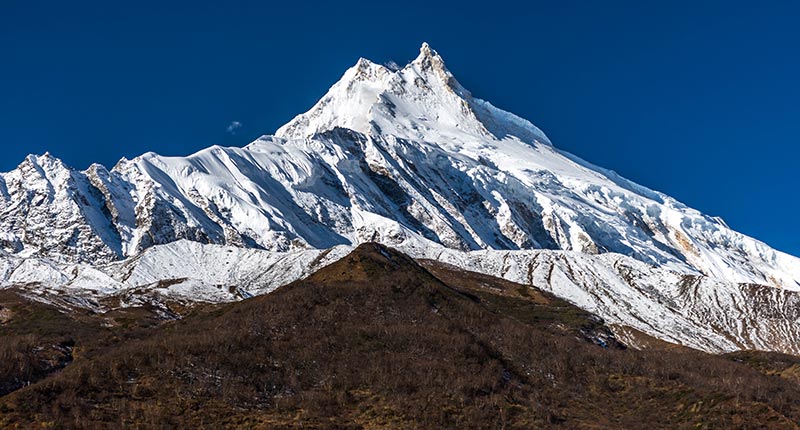
The trekking continues in between the dense sub alpine forest crossing small streams around. We can see a lot of snow capped peaks alongside Kutang,PangPuchin,Saula to name some of them. The gradual uphill trek and we reach another small settlement village Sho. We can see the massive mountain Manaslu(8163m) for the first time just before reaching Lho, with numerous peaks. Lho is moderately big village on upper region of Manaslu. Highly influenced by Tibetan lifestyle and rich in manis and chortens which we usually see in upper trekking region of Nepal.
We again enter dense subalpine forest leaving behind the Lho and climb for about an hour. Trekking trail is narrow slippery and difficult but the view of peak 29 and Mount Manaslu excites you rather. The tall tree line gradually disappears and small alpine trees are seen ahead of reaching Shyla a open and flat land. You can feel the drop-in temperature and change in vegetation and landscape as you reach Shyla. After crossing suspension bridge on Shyla you just enter the vast valley of Manaslu with huge pasture lands and can see Samagaon village far away. You see a lot of thatched roof houses along with manis and chortens with stone carved slates as you reach Samagaon.
Samagaon is the biggest and most populated village in upper Manaslu region which is also a hub for Manaslu expeditions. Most of the people are dependent upon tourism agriculture and animal husbandry for their livelihood. People around here seem to adopting Tibetan culture and tradition but has its own uniqueness and narration. Today we make casual short hike to Pungyen Gompa to acclimatize and see the beauty of Manaslu. We return back to Samagaon.
As we gain altitude, the trekking hour is short to adopt your body and mind in changing environment. The trekking day is easy from Samagaon to Samdo in vast open meadow with sparse juniper bushes. You can see Himalayan Marmot in abundance running around the fields. The Mount Manaslu seems to be more beautiful and fresh than ever seen before. Samdo village just lies on the foothill of Samdo-ri Peak. Samdo village used to be a economic hub for Tibetan and Nepalese merchant in ancient days for trading since Tibetan boarder is nearby. The upper hill region of Samdo is believed to be rich in snow Leopard.You take short hike around the ridges of Samdo village to amplify the acclimatization.
The trekking path seems to be much easier and flat but the gain in altitude again makes your every step heavy and slow. We pass Larkey Bazar which used to be ancient temporary market place for ancient merchants of Tibet and Nepal but not longer now. We see vast meadows with yak herds grazing all around. People make temporary huts to look after their yaks down on the valley. Again we can see beautiful mount Manaslu along with Samdo-ri, Larkey, Himlung ,peak 29 to name few of them. Dharmashala is not exactly comfortable place to spend night with only one stone house and tent house but we are out of option.
We start our day early in the morning just by the side of Larkey peak on the left and Himlung on the right. The morning is freezing cold. The climb is gentle yet requires a lot of energy. The path is rocky and icy and we can see the Larkey glacier in the nearest point possible with ice lake at the bottom of glacier. The prayer flags are seen at the top for indicating Larkey-La pass. We can see outstanding view of AnnapurnaII, Himlung, Cheo and Kang guru from the top. The path gradually descends and becomes steeper down to Bhimthang. The alpine vegetation reappears as we trek down to Bhimthang. Bhimthang is small settlement in flat meadow which looks beautiful as we trek down. The peak 29 and Manaslu appears to be totally different and amazing than we had seen before.
Today our trekking route descend down to reach Tilje .The upper temperate forest reappears and the day becomes more warmer as we leave Bhimthang. Rhododendrons, alpine pine trees dominate other vegetation. The terraced crop fields are seen around Kharche.We steep climb up the ridge and again trek down the Marshyangdi river to reach Tilje.
The trail is gentle as we ascend to Dharapani. After an hour walk we cross the suspension bridge and reach Dharapani. It is a junction that divides Annapurna and Manaslu trekkers. The classic trekking trail has been ruined by the access of vehicles around this section of trekking route. As we descend the valley appears deep and narrow with raging Marshyangdi river. Tal is situated in the flat bank of Marshyangdi river. Mainly inhabitant of Gurung people, Tal is also a settlement for long back migrated Tibetan highly influenced from the culture and tradition from Mananag .People grows potatoes,corn,barley for household purposes beside engaging in tourism.
From Tal we generally see the hilly landscape of Nepal. Trekking in between towering hilly cliffs is itself a exciting. Small and big waterfalls are something to capture in camera. Abundance terraced farm land looks beautiful. Walking through small ascends and descends you reach Syange. You can enjoy the last trekking dinner with guide and porter as a tribute to their hard work for making your trekking successful
We drive gravel and dusty zigzag road from Syange until we reach Besisahar along the side of Marshynagdi river. Besisahar is a commercial town for people around Manang and upper belt of Manaslu region.After Besishar the road is fairly easy on asphalt road as we drive to Kathmandu. Numerous swift rivers are seen on the way perfect to give a try for Rafting in one of them if you have any energy left.
Our office representative will be in your hotel 3 hour prior your flight time to drop you at Tribhuvan International Airport.
what's included?
- All Airport Transfers.
- Accommodation in Kathmandu with Bed and Breakfast.
- Tea House Accommodation during Trekking.
- 3 Meals in Trekking Breakfast Lunch & Dinner.
- Road transportation as per the agreement made.
- All the necessary trekking staffs and porters for the trekking including 1 English speaking guide.
- All the paper works and documents required for the trekking including all the permits.
- Sleeping Bag.
- Salary, wages, food, accommodation and transportation of all the Nepalese staffs during trekking.
- Insurance of all the Nepalese staffs during trekking.
- First Aid Kit Bag(specially for Nepali staffs).
- All local taxes and fares.
What's not included?
- International Flight Fare.
- Visa fees.
- Travel Insurance (mandatory) of all the clients that needs to cover medical and Helicopter evacuation.
- Expenses of Personal nature (Laundry bill/Telephone bill/Equipment Charging Bill/Bar bill etc).
- Expenses incurred due to the unexpected situation (Strike/Natural calamities).
- Tip to trekking staffs.
- All Expenses not mentioned on Cost Includes section.
Frequently Asked Questions (FAQs) on Round Manaslu Trekking
1. What is Round Manaslu Trekking?
Round Manslu trekking get the name after the Mount Manaslu 8163m. The trekking route encircles the Manaslu on 360 degree angle with maximum view of the mountain possible.
2. How can I go to Round Manaslu Trekking?
Road transportation is the only available option to go to Manaslu trekking.Driving equally on asphalt and gravel road to Sotikhola from where the trekking starts the next morning.
3. What is the landscape features of Round Manaslu trekking in general?
The trekking that starts from tropical region with dense forest, terraced crop fields alongside the Budhi Gandaki river. The trekking continues to one of the hostile, unfavorable yet beautiful landscape on Larkey La pass( 5106m) and descends to Marshyangdi valley from Dharapani.
4. Why Round Manaslu trekking is popular itinerary?
Round Manaslu trekking is much more similar to Annapurna Round trekking. Moreover, the trekking route is less crowded and less commercialized than Annapurna region. As well the cultural and traditional aspects are better preserved .Recently, this trekking has been great option to Annapurna round trekking.
5. What kind of weather and temperature can I expect during trekking?
The weather and temperature is highly unpredictable on mountain but generally during March April May (spring) and September October November (autumn) you can expect clear and warm day while evening will be cloudy and cold. The temperature is freezing in morning and evening in upper trekking region while lower region is considerably cold.
6. What equipments do I need to trek to Round Manaslu Trekking?
Good pair of trekking boots, thermal wear, fleece jacket, Down jacket, light weight wind cheater, trekking pants and shorts, long sleeve and short sleeves T-shirts, rug sack or duffle bag, personal day bag, gloves, enough pair of socks, sunglasses, headlight, woolen beanie caps, water bottle, personal toiletries , gadgets and books depending on number of days .
7. I am amateur trekker in Nepal, is this trekking suitable for me?
Yes amateur trekker can trek to Manaslu under our strict guidelines without any difficulties.
8. How flexible is Round Manaslu trekking itinerary?
There is always possibility to add or remove 1-2 days on this standard itinerary with exchange of some emails. But we will never compromise with the safety issue of clients neglecting the delicacy of this trekking region.
9. What if I finish Round Manaslu trekking before schedule date?
We strongly advise you to follow the agreed final itinerary since we do not refund the trekking money. But somehow if you finish trekking earlier, we will always try our best to adjust the reservation of your accommodation in Kathmandu but cannot be guaranteed.
10. What permits and documents do I need to trek to Round Manaslu trekking?
Special permit issued by the Department of Immigration, Annapurna Conservation Area Permit (ACAP), Manaslu Conservation Area Permit (MCAP) and Trekking Information Management System (TIMS) card is required to trek on this region.
11. What kind of food and Room can I expect during Round Mansalu trekking?
Generally the food is fresh, tasty and can choose wide range of dishes from menu cooked by moderately professional cooks. You will get comfortable and clean common twin bed room throughout trekking . However, Dharmashala is extremely busy with single tea house.The tea house is very poor so a night can be a dreadful experience.
12. What about drinking water during trekking?
Plastic water bottle are available in tea houses but it is highly recommended to avoid plastic bottles and use boil water instead. As well you may buy high grade water purification tablets on your home country or in Nepal.
13. What can I expect from Nepali staff?
Guide speaks good English so there will be no any problem for communication while porter might or might not speak English .You can always speak with your guide to know more about the porter if you like. Nepalese trekking guide are friendly and responsible with good sense of humor so you can open up for any conversation you like.
14. Do I need to buy Medical and evacuation Insurance?
Yes this is mandatory. You can purchase the insurance policy on your home country or we can assist you to buy the policy in Nepal.
15. Do I need special vaccination or Medical assessment before starting Round Manaslu trekking?
Generally any kind of vaccination is not required. But,if you have long term health problem and under regular surveillance of your doctor it is recommended to consult your doctor. Though we provide basic medicines to our Nepalese staff but for you we advise to bring the general medicine from your own country.
16. Is there risk of Acute Mountain sickness (AMS)?
Yes there is high risk of Acute Mountain Sickness (AMS). Especially,if you choose random trekking itineraries and do not follow the standard itinerary. But we always provide you the best and safe itineraries to avoid this deadly situation.
17. What should I do if I get Acute Mountain Sickness (AMS)?
We are always concerned with your safety. We suggest talking with your guide ASAP and descend to safe altitude. If the situation doesn’t get any better we evacuate you immediately with helicopter.Hence, take you for further medical examination to designated hospitals and clinic.
18. What is the price of Round Manaslu Trekking?
We have provided you various options on our website to know approximate price regarding the trekking in Nepal; however there is always room to reach final agreement through private emails if there is any. And we assure you there will be no any extra cost once we reach the agreement.
You are always welcome to send us private messages for the information that you could not find in this section regarding Round Manaslu trekking. We will always provide the accurate information within 12 hours upon receiving your messages.
CANCELLATION
Free cancellation up to 60 days prior departure, after which the deposit becomes non-refundable.