21 days Classic Annapurna Round Trekking
Extermly Popular
Classic Annapurna Round Trekking is a long, traditional and classic (vintage) trekking itinerary of 21 days. The trekking path encircles the entire Annapurna trekking region. Moreover, two famous valleys Marshyangdi valley and Kaligandaki valley are joint by the famous thrilling Thorong-La(5416m) pass at the heart of the Himalayas.
The Classic Annapurna Round trekking is very popular among the trekker due to the diversified landscapes and vegetation. Doubtless, the long 21 days itinerary covers maximum area of Annapurna Conservation area. Starting from tropical climatic zone of Marshyangdi valley, trekker gradually enters temperate, alpine and snowline including a section of Trans-Himalaya landscape. The flora and fauna adapt respectively. The lower region has temperate forests while the sub-alpine region has coniferous forest. The alpine region has vast meadows with grasslands and small bushes. The snowline region is icy and rocky. While the trans-Himalaya region has barren sandy and dry land.
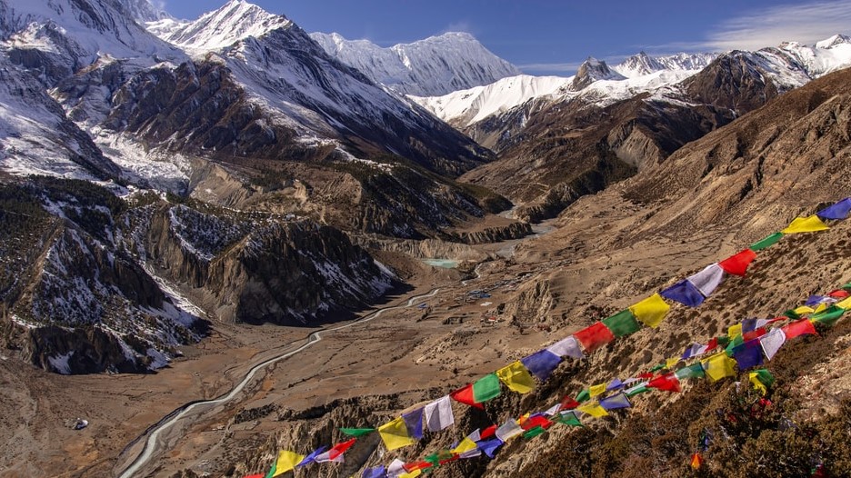
Upon crossing Thorong-La pass, trekker descends to Kaligandaki valley. Mount Dhaulagiri(8167m) and Mount Annapurna(8091m) along with other numerous peaks dominate the valley. Jomsom and Marpha villages in Kaligandaki valley have the Trans Himalaya climatic zone. The Classic Annapurna round trekking also includes Poonhill and Ghorepani. The region from where trekker can summarize the Annapurna region equally can enjoy the beautiful countryside villages of Himalaya. Trekking on two different valleys gives an opportunity to experience an entirely different class of landscape, flora, fauna and human habitat along with their cultures, traditions, and lifestyles on Himalaya.
Hinduism is the main religion in the lower trekking region of either valley. Brahamin, Chhetri, Gurung and other mixed ethnic communities live in great harmony. Buddhism dominates the upper trekking region. Importantly, the settlements are highly confined in the upper trekking region. In big settlements like Pisang, Manang of Marshyangdi valley and Jomsom, Marpha of Kaligandaki valley one can see a fraction of Tibetan culture and traditions.
Moreover, the popularity of classic Annapurna Round trekking itinerary is diminishing after construction of road in the region. The number of trekking days has become significantly short on either of the two valleys. There are numerous itineraries options available in this classic trekking path to complete Annapurna Round trekking. However, Classic Annapurna round trekking itinerary is an option to our valued trekkers to enjoy the classic and traditional route of famous Annapurna Round Trekking.
Outline Itinerary
Day 1 International Arrival in Kathmandu(1300m)
Day 2 Sightseeing in Kathmandu,Permit preparation day, briefing by official executive, handing assignment to guide.
Day 3 Drive from Kathmandu to Bhulbhule(850m)
Day 4 Trek from Bhulbhule to Syange(1135m)
Day 5 Trek from Syange to to Tal(1710m)
Day 6 Trek from Tal to Bagarchhap(2080m)
Day 7 Trek from Bagarchhap to Chame(2710m)
Day 8 Trek from Chame to Pisang(3300m)
Day 9 Trek from Pisang to Manang(3520m)
Day 10 Acclimatization day in Manang(3520m)
Day 11 Trek from Manang to Yak Kharka(4210m)
Day 12 Trek from Yak Kharka to Thorong phedi(4640m)
Day 13 Trek from Thorong phedi to Muktinath(3800m) Via Thorong –La pass(5416m)
Day 14 Trek from Muktinath to Marpha(2670m)
Day 15 Trek from Marpha to Kalopani(2530m)
Day 16 Trek from Kalopani to Tatopani(1200m)
Day 17 Trek from Tatopani to Ghorepani(2850m)
Day 18 Trek from Ghorepani to Tikhedhunga (1495m)
Day 19 Trek from Tikhedhunga to Nayapul and drive to Pokhara(850m)
Day 20 Drive/fly to Kathmandu from Pokhara
Day 21 International Departure
Note: This is a standard itinerary proposed for general trekkers which can be modified until then, that do not violate our business ethics and norms. We will always seek verification from our field experts before approving your itinerary.
Detailed Day to Day Itinerary
We will drive you straight to your hotel in private vehicle as soon as you land at Tribhuvan International Airport of Kathmandu. We will give you short briefing on our final agreed program. And if you are the first time traveler in Nepal we will give information about restaurant, ATM, money exchanges and other useful information until we meet for next day.
There are various major cultural historical and religious places around Kathmandu, Lalitpur and Bhaktapur for sightseeing. Pashupatinath, Bauddhanath, Swayambhunath, Bhaktapur Durbar Square,Kathmandu Durbar Square and Patan Durbar square are our top lists. Most of them are listed on UNESCO world heritage sites. Later in the evening we will arrange dinner with your trekking guide so you can know each other and talk about your trekking itineraries.
After your breakfast, we drive to Westside of Nepal on zigzag hilly road by the bank of Trishuli and head north following Marshyangdi river to reach Besisahar from Dumre.It takes 6 hr drive to reach Besisahar a well developed town from where most of the economic and administration works are handled. An hour drive from Besisahar on dusty and off-road takes you to Bhulbhule.
Crossing a suspension bridge from Bhulbhule the path continues by the bank of Marshyangdi river with terraced paddy fields seen around. We may see the first glimpse of Mount Manaslu on horizon. Waterfalls accompanied by deciduous forest on hilly slopes of lower temperate region makes the trekking beautiful. We climb a steep hill to reach Bahundanda (literally hill of Brahmins) after crossing suspension bridge in Lampata. The trail again descends to reach Syange by the bank of Marshyangdi river that rejoins with jeep road.
The path is steep climb from Syange to Jagat. The trekking trail alongside the dusty jeep roads which sometime get on your nerves but the dense forest with beautiful waterfalls and towering cliffs make the trekking wonderful. The path combines small ascends and descends to reach another settlement at Chamje, from where you will steep climb for an hour and cross suspension bridge to reach Tal a settlement by the bank of Marshyangdi River where we can see fraction of Tibetan culture and tradition inspired from Manang valley.
The trekking is fairly easy and gentle from Tal to Dharapani. The trekking continues by the bank of river with numerous waterfalls seen on the way with beautiful rock canyons. We will trek about three and half hours to reach Dharapani an intersection for Manaslu and Annapurna trekking. From Dharapani vegetations are mostly accompanied by Lower Temperate forest of chir, pine ,maples,broken by few sub alpine trees.
The trekking path from Bagarchhap to Danaque is flat and easy then we abandon jeep road to climb a steep up accompanied by rhododendron forest to reach a beautiful place Timang. Rocky cliffs adjacent to peaks and mountains reallystarts to appear beautiful on horizon as you trek in pine forest. Lamjung Himal (6983m), Annapurna II (7937m) and Annapurna IV (7525m) are spotted which will continue to appear and disappear till the end of trekking. Chame is beautiful large settlement which is also an administrative headquarter of Manang district.
Leaving behind chortens and mani walls in Chame we trek on rocky and steep canyons for few hours in deep and narrow valley to reach Bhartang.We cross a suspension bridge and climb steep slope in between pine forest for about 2 hour and then the trail becomes more gentle and easy to reach Pisang ; village surrounded by Chulu and Pisang peak.The day becomes clearly interesting as trekking path from Upper temperate region enters to sub alpine region with wide valley accompanied by shallow vegetation.
There are two different routes to reach Manang from Pisang.The ideal route would be upper trail through Gheru and Ngawal since this route offers you the unrestricted parallel view of mountains. Though you need to climb steep for an hour to reach Gheru it is highly recommended for the scenic views of Gangapurna, Pisang peak, AnnapurnaII AnnapurnaIII and Chulu peak on horizon and Marshyangdi valley at deep bottom.Due to poor rainfall and cold weather the sub alpine vegetation seems dry and significantly different with sparse pine trees .The trekking path is easy with small up-downs in between pine trees to reach Ngawal from where it takes about 2 hour to reach Manang.
In order to adopt our body with new environment ,humidity,temperature and altitude it is highly important to acclimatize yourself. Manang would be wonderful place to have a rest day in overall considering the altitude and beauty of this region. The forthcoming two days is really challenging part of this trek since we have got pass ahead and we will be gaining more altitude. It is always better to have a easy short hike around rather than staying still to avoid altitude sickness. The major mountains that can be noted down today would be Annapurna II, Annapurna III (7,555 m), Gangapurna (7,454 m ) to the South , Tilicho (7,132 m) , Chulu West (6,583 m), Chulu East (6,059 m) to the North .
Yak Kaharka literally is a pastureland for the cattle. It will take around 4 hr to reach Yak Kharka from Manang with short and steep climb .You will climb gradually northward leaving the Marshyangdi Valley behind. The trekking continues in meadows accompanied by the small juniper bushes offering you the magnificent landscape along with AnnapurnaII AnnapurnaIII AnnapurnaIV and Gangapurna .Upon reaching Yak Kharka you may take short hike above the ridges to amplify the acclimatization.
You climb gradually up towards the head of Valley to reach the Thorang Phedi which takes around 4 hr walk from Yak Kharka. After crossing the suspension bridge, the winding narrow path continues with the Thorong Khola deep in Thorang Valley. The landscape becomes much more hostile and fragile with steep slopes which have been eaten by ancient glacier. Throrang phedi welcomes you with chorten ,you may relax on your own or can hike up to high camp.
We start early morning since you will have long and relatively hard day. Most importantly, the weather could dramatically change in high altitude. One hour climb from Thorang phedi leads you to High Camp (4830m), where you can take a short tea break to warm yourself. The path seems easy and gentle but the altitude makes the trekking slower and tiring. After 2 hr walk from High camp, the dancing prayer flags could be seen from far away Thorong-La pass (5416m)which offers themagnificent view of Thorong peak,Yakwakang peak,chulu west. After congratulating and picture session we trek down about 4 hr to reach Muktinath enjoying the vast Kaligandaki valley.
Muktinath is holy site equally important to Hindu and Buddhist piligrims.It is worthy to visit the Muktinath temple in the morning before descending Jomsom.You can see lot of Hindu and Buddhist people taking bath in icy cold water. You can see massive Mount Dhaulagiri(8167m) dominating the wide Kaligandaki valley. While trekking down you can notice the fraction of Trans Himalaya zone till you reach Marpha enjoying the view of Nilgiri ranges. The region is primarily inhabitant of Thakali people. Jomsom and Marpha is the landmark for apple production. Marpha is typically neat and clean small village with cluster of uniform houses.
The trekking trail is gentle down by the bank of Kaligandaki river on dry and dusty path. We pass many small settlements of indigenous Thakali people enjoying entirely new landscape on this region. Nilgiri ranges ,Tukuche peak,Dhaulagiri are seen on horizon while we gradually enter upper temperate region accompanied by juniper, pine, fir forest. The valley gradually deepens making Kaligandaki river speedier and as we trek down to Kalopani.
Beautiful Tukuche peak,Nilgiri peak,and Dhaulagiri are seen on your back as our trek continues downhill. The trekking becomes more interesting as Kaligandaki river disappears down in between deep gorges. The trekking continues with green lush vegetation accompanied by waterfalls and towering hills. Gradually the farming terraces appears and the trekking trail becomes more flat familiar and gentle. Annapurna south AnnapurnaI emerges just before reaching Tatopani a hot spring spot. Grab your things and soothe your body on hotspring with chill beer.
Today the day is little bit harder and longer.Crossing a bridge and walking by the bank of Kaligandaki river you will reach Ghar Khola.From Ghar Khola it is steep climb to reach the top of hill from where the magnificient Kaligandaki valley is seen at the bottom. The trekking continues to ascend to Ghara a bigger settlement of Magar and Brahamin where the farming has been major occupation for livelihood.Dhaulagiri and Tukuche peak are seen more admiring as you pass by numerous settlement and terraces of crop fields. The trekking is gradually uphill in between rhododendron and pine forest till you reach another big settlement of Gurung community Ghorepani.
Today you will climb to Poonhill early in the morning to see magnificent sunrise which is about an hour walk. The earliest sun ray that strikes the mountain and peaks makes them to appear cluster of orange gemstones; Mount Dhaulagiri, Mount Annapurna, Fishtail, Tukuche, Nilgiri and other snow capped peaks looks really glamorous. Returning back to Ghorepani the trekking is down in between damp forest of rhododendron that continues to another Magar settlement Ulleri. The trekking is steep down from Ulleri on stone stairs to reach Tikhedhunga. You can enjoy the last trekking dinner with your guide and porter as a tribute to their hard work for making your trekking successful.
We start our journey upon taking breakfast and proceed to down Nayapul enjoying the hilly part of Nepal. We continue walking terraced crop fields followed by subtropical and tropical landscape. From Nayapul we take a private vehicle to reach Pokhara which takes about one and half hour drive. Upon arrival in Pokhara you can take evening walk on the lakeside which is always a happening place for tourists.
From Pokhara either you can take a short flight or take a private transportation to Kathmandu accordingly to the agreement we made before the start of trek.
Our office representative will be in your hotel 3 hour prior your flight time to drop you at Tribhuvan International Airport.
what's included?
- All Airport Transfers.
- Accommodation in Kathmandu & Pokhara with Bed and Breakfast.
- Tea House Accommodation during Trekking.
- 3 Meals in Trekking Breakfast Lunch & Dinner.
- Air and Road transportation as per the agreement made.
- All the necessary trekking staffs and porters for the trekking including 1 English speaking guide.
- All the paper works and documents required for the trekking including all the permits.
- Sleeping Bag.
- Salary, wages, food, accommodation and transportation of all the Nepalese staffs during trekking.
- Insurance of all the Nepalese staffs during trekking.
- First Aid Kit Bag(specially for Nepali staffs).
- All local taxes and fares.
What's not included?
- International Flight Fare.
- Visa fees.
- Travel Insurance (mandatory) of all the clients that needs to cover medical and Helicopter evacuation.
- Expenses of Personal nature (Laundry bill/Telephone bill/Equipment Charging Bill/Bar bill etc).
- Expenses incurred due to the unexpected situation (Strike/Natural calamities).
- Tip to trekking staffs.
- All Expenses not mentioned on Cost Includes section.
Frequently Asked Questions (FAQs) on Classic Annapurna Round Trekking
1. What is Classic Annapurna Round trekking?
Annapurna Round trekking receives the name after the Annapurna Himalaya range and the word “round” which generally means encircling the Annapurna Mountains along with other peaks and mountains.Classic signifies the traditional and old trekking route before construction of road.
2. How can I go to Classic Annapurna Round Trekking?
You can drive on local or private vehicle to Bhulbhule and start your trekking next day.
3. What is the landscape features of Annapurna Round Trekking in general?
The trekking that starts from tropical region with dense forest, terraced crop fields through Marshyangdi valley heads to one of the hostile, unfavorable yet beautiful landscape on ThorongLa pass( 5416m) and descends to Kali Gandaki valley.
4. Why Classic Annapurna Round Trekking is so popular?
The easy access to one of the most beautiful landscape on Himalaya , dense forest, terraced farm,mixed Nepali culture and tradition with numerous close views of mountains and peaks has kept this trekking extremely busy.
5. What kind of weather and temperature can I expect during trekking?
The weather and temperature is highly unpredictable on mountain but generally during March April May (spring) and September October November (autumn) you can expect clear and warm day while evening will be cloudy and cold. The temperature is freezing in morning and evening in upper trekking region while lower region has tolerable cold.
6. What equipments do I need to trek to Classic Annapurna Round trekking?
Good pair of trekking boots, thermal wear, fleece jacket, Down jacket, light weight wind cheater, trekking pants and shorts, long sleeve and short sleeves T-shirts, rug sack or duffle bag, personal day bag, gloves, enough pair of socks, sunglasses, headlight, woolen beanie caps, water bottle, personal toiletries , gadgets and books depending on number of days.
7. I am amateur trekker in Nepal, is this trekking suitable for me?
Yes amateur trekker can trek to Classic Annapurna Round under our guidelines without any difficulties.
8. How flexible is Classic Annapurna Round trekking itinerary?
The access of gravel road has considerably shorten the trekking days so currently this is the most flexible itineraries that trekkers can expect in Nepal in between 13 to 21 days.
9. What if I finish Classic Annapurna Round trekking before schedule date?
We strongly advise you to follow the agreed final itinerary since we do not refund the trekking money, but somehow if you finish earlier we will always try our best to adjust the reservation of your accommodation and flight but cannot be guaranteed.
10. What permits and documents do I need to trek to Classic Annapurna Round?
Annapurna Conservation Area Permit (ACAP) and Trekking Information Management System (TIMS) card is required to trek on this region.
11. What kind of food and Room can I expect during Classic Annapurna Round trekking?
Generally the food is fresh, tasty and can choose wide range of dishes from menu cooked by moderately professional cooks. You will get comfortable and clean common twin bed room throughout trekking but upper trekking region has countable tea houses and is extremely busy so sometime it is really difficult to get good rooms.
12. What about drinking water during trekking?
Plastic water bottle are available in tea houses but it is highly recommended to avoid plastic bottles and use boil water instead, as well you may buy high grade water purification tablets on your home country or in Nepal.
13. What can I expect from Nepali staff?
Guide speaks good English so there will be no any problem for communication while porter might or might not speak English but you can always speak with your guide to know more about the porter. Nepalese trekking guide are friendly and responsible with good sense of humor so you can open up for any conversation you like.
14. Do I need to buy Medical and evacuation Insurance?
Yes this is mandatory. You can purchase the insurance policy on your home country or we can assist you to buy the policy in Nepal.
15. Do I need special vaccination or Medical assessment before starting Classic Annapurna Round trekking?
Generally any kind of vaccination is not required. But,if you have long term health problem and under regular surveillance of your doctor it is recommended to consult your doctor. Though we provide basic medicines to our Nepalese staff but for you we advise to bring the general medicine from your own country.
16. Is there risk of Acute Mountain sickness (AMS)?
Yes there is always risk of Acute Mountain Sickness (AMS) especially for amateur trekkers if you choose random trekking itineraries and do not follow the standard itinerary.But we always provide you the best and safe itineraries to avoid this deadly situation.
17. What should I do if I get Acute Mountain Sickness (AMS)?
We are always concerned with your safety. We suggest talking with your guide ASAP and descend to safe altitude. And if the situation doesn’t get any better we evacuate you immediately with helicopter. Hence, take you for further medical examination on designated hospitals and clinics.
18. What is the price of Classic Annapurna Round Trekking?
We have provided you various options on our website homepage to know approximate price regarding the trekking in Nepal; however there is always room to reach final agreement through private emails if there is any. And we assure you there will be no any extra cost once we reach the agreement.
You are always welcome to send us private messages for the information that you could not find in this section regarding Classic Annapurna Round Trekking. We will always provide the accurate information within 12 hours upon receiving your messages.
CANCELLATION
Free cancellation up to 60 days prior departure, after which the deposit becomes non-refundable.