25 days Saribung Peak Climbing
Saribung Peak climbing itinerary combines trekking in two Trans-Himalaya regions along with climbing Saribung Peak (6328m). Unlike other peak climbing, it actually focuses on trekking rather than solely in peak climbing. Saribung peak climbing is itself not a difficult and technical but, trekking in two remote, isolated Trans-Himalaya climatic zone of Upper Mustang and Phu valley is. Especially, the trekking section in between Ghuma Thanti and Phu valley.
Newly discovered and popular, the lengthy trekking itinerary provides an exceptional way to explore around two Trans-Himalayan regions with thrill of peak climbing in single session.
The two Trans-Himalaya region of Mustang and Phu is joint by Saribung pass (6050m). The Saribung peak climbing itinerary starts upon flying to Jomsom. Exploring the beautiful valley, landscape and villages of Upper Mustang, trekking stretches to snowline and remote part of Mustang. Upon successful summit of peak (6328m), the trekking continues to another remote Phu Gaon. Again, exploration and trekking around Phu valley don’t happen regularly and frequently for general trekker. The trekking finally descends to Koto of Annapurna round trekking and ends at Tal.
Importantly, the itinerary is popular for trekking rather than peak climbing. The trekking is full of adventure and thrill. Saribung peak climbing is great opportunity to explore some remote, hidden section of deep Himalayan region of Nepal. Plus, combining two different trekking region, Mustang, and Phu, trekker can experience different cultural, traditional and natural aspects of Himalaya. Importantly, each region with own identity and characteristics.
However, the Saribung peak climbing and trekking in the section of Upper Mustang and Phu certainly demands a good physicality and mentality from trekker. The trekking is highly remote. The long trekking itinerary can also be a set-back for some trekkers.
In contrast, the itinerary can be absolutely boon for trekker who wants to skip busy trekking regions of Nepal. Saribung peak climbing can be as much adventurous as Base camps and Circuit treks of Nepal. More importantly, trekking in two popular yet remote destinations of Nepal in single trekking itinerary does not happen often.
Outline Itinerary
Day 1 International Arrival in Kathmandu (1300m)
Day 2 Sightseeing in Kathmandu,Permit preparation day, briefing by official executive, handing assignment to guide
Day 3 Drive/ Flight to Pokhara (850m)
Day 4 Short flight from Pokhara to Jomsom (2715m) and trek to Kagbeni (2810m)
Day 5 Trek from Kagbeni to Chele (3080m)
Day 6 Trek from Chele to Ghiling (3570m)
Day 7 Trek from Ghiling to Charang (3560mm)
Day 8 Trek from Charang to Lo-Manthang (3810m)
Day 9 Reserve day for Exploration around Lo-Manthang (3810m)
Day 10 Trek from Lo-Manthang to Yara (3650m)
Day 11 Trek from Yara to Luri Gompa (4000m)
Day 12 Trek from Luri Gompa to Ghuma Thanti (4600m)
Day 13 Trek from Ghuma Thanti to Parsye Khola (4850m)
Day 14 Trek from Parsye Khola to Damodar Kunda (4890m)
Day 15 Trek from Damodar Kunda to Japanese Base camp ( 5360m)
Day 16 Trek from Japanese Base camp to High camp (5780m)
Day 17 Summit Saribung peak (6328m).Trek to Bhrikuti Base camp (5070m)
Day 18 Trek from Bhrikuti Base camp to Phu Gaon (3995m)
Day 19 Rest Day at Phu Gaon (3995m)
Day 20 Trek from Phu Gaon to Meta (3560m)
Day 21 Trek from Meta to Koto (2615m)
Day 22 Trek from Koto to Tal (1710m)
Day 23 Drive from Tal to Kathmandu (1300m)
Day 24 Free Day in Kathmandu (1300m)
Day 25 International Departure
Note: This is a standard itinerary proposed for general trekkers which can be modified until then, that do not violate our business ethics and norms. We will always seek verification from our field experts before approving your itinerary.
Detailed Day to Day Itinerary
We will drive you straight to your hotel in private vehicle as soon as you land at Tribhuvan International Airport at Kathmandu. We will give you short briefing on our final agreed program. And if you are the first time traveller in Nepal we will give information about restaurant, ATM, money exchanges and other useful information until we meet for next day.
There are various major cultural historical and religious places around Kathmandu, Lalitpur and Bhaktapur for sightseeing. Pashupatinath, Bauddhanath, Swayambhunath, Bhaktapur Durbar Square, Kathmandu Durbar Square and Patan Durbar square are our top lists. Most of them are listed on UNESCO world heritage sites. Later in the evening we will arrange dinner with your trekking guide so you can know each other and talk about your trekking itineraries.
If you want to drive to Pokhara it is always better to start in the morning after your breakfast, it will be little tiring day due to 6-7 hour drive. Driving from Kathmandu offers you to enjoy interesting zigzag road of hilly part of Nepal along with diversified culture, landscape and people all the way to Pokhara. The flight is short from Kathmandu to Pokhara but you can have leisure time to spend around lake-side of Pokhara, which is always a happening place for the visitors.
20 min flight from Pokhara and you will reach Jomsom, headquarter of Mustang. The trans Himalaya climatic landscape appears as soon as you land at Jomsom. Mount Annapurna,Mount Dhaulagiri,Fishtail & Nilgiri could be noticed from your aircraft window. All the administrative and government work in the Mustang district is operated from here. As far you trek forward from Jomsom the landscape becomes more barren and isolated.The bank is widely eroded due to the Kaligandaki river.The afternoon is really windy and dusty as your trek start.After couple of hour easy walk and you will reach Kagbeni.
The trekking trail stretches vividly by the bank of Kaligandaki river. We ascend and descend proportionally and climb a northern ridge just before reaching Tangbe village. The only greenery seen around are the seasonal crop fields mainly buckwheat, barley and potatoes accompanied by few backyard apple garden. An hour walks from Tangbe then we reach to another settlement of Chhusang. Cross a suspension bridge and climb steep up to reach interestingly located human habitat at the top of cliff;Chele.
Today we climb three different passes Taklam La(3625m) Dajori La(3735m) and Yamda La (3850m) which offer magnificent landscape of Mustang region. The trail is steep up from Chele and the trail flattens up just before descending down to rocky river canyon to reach another settlement of Samar village then we climb rocky canyon to reach Syangbochen .From Syangbochen we again ascend to Yamda-La and gradually descend down to reach Ghiling which takes little more than an hour.
We visit a monastery at Ghiling which has nothing much special but has some nice paintings of Shakya Buddhism.From Ghiling we climb up the valley to reach Nya-La pass (4010m) from where beautiful Annapurna, Nilgiri and Mustang ranges are seen .The trail descends further more to reach another big and beautiful village of Mustang region Ghami. By the afternoon the cloud may block the mountains that surround the village.The trail further descends from Ghami and after crossing suspension bridge, we can see the long and beautiful manis wall, the path gradually ascends to reach another pass Charang-La(3870m) . An hour walks from the pass to reach Charang
After visiting few interesting old gompas and Chortens in Charang ,our trek descend steep down cross suspension bridge and again climb steep up. The trekking path is fairly easy and gentle as it ascends to another pass Lo-La(3950) from where you can see beautiful Lo-Manthang for the first time. Nilgiri,Tilicho and Annapurna I are also visible from the pass. Descend down to reach hidden kingdom of Nepal Lo-Manthang.
Lo-manthang is itself very rich in ancient architectural designs whether it is about chortens or monasteries or even houses. All of them represent unique historical norms and values even in this modern era.Thanks to the hard work of all those specialists who are trying to preserve and restore all those heritages. Today we do village tour and visit three significant gompas Chhoeda, Jhampa and Thupchen each has own history and story .Numeorus ancient mandalas,statues,Thangkas and painting decorates the Gompas extensively.
We leave behind Lo-Manthnag and retrace our steps to Lo-La pass (3950). Enjoying the spectacular ridges and canyons trekker turns left and descends to Dhi village. The Dhi village looks beautiful and greener with seasonal cultivation around such a hostile and barren land by the bank of Puyun khola.The trekking gradually descend leaving the river bed and continues to the settlement of Yara gaon. The numerous caves on the high cliffs are spectacular and amazing. Reaching Yara exploration around the ridges of village is always a good idea.
The trekking hour is comparatively short today. We head north side of Puyun khola and explore around Tashi Kabum. The cave is highly decorated with historical wall paintings and ceiling paintings. Upon capturing some pictures we continue easy walk to Luri Gopma. Highly religious and significant place for Buddhist. Firstly, we visit the cave temple that has mandalas, wall paintings, ceiling paintings and chortens of high historical importance. Next we visit a modern Luri Gompa passing through old chortens just below Luri cave monastery
The trekking day becomes longer and gain significant altitude comparing past few days of our trekking. First we descend to the Puyun Khola and gradually climb up hill crossing the river. Walking through small patches of green shrubs we reach a ridge (pass??) at altitude of 4940m. The ridge is spectacular to capture the Trans-Himalayan landscape surrounded by numerous peaks. The trekking again follows a winding path and gradually descend to reach a Ghuma Thanti. A rest house for Buddhist and Hindus pilgrimages for Damodar Kunda.
The day is relatively easy. If you haven’t walked through ice before, could be the day. We walk through a gully in between small ridge to reach Kyumu pass at height of 5320m.On a clear day, trekker can spot Mount Annapurna and Mount Dhauligiri on horizon including Damodar peak. Briefly, yet we steeply descend down to reach Parsye Khola our campsite. The place is surrounded by high and rocky cliffs. Trekker have sufficient day left to explore the surrounding of river bed on their own.
We climb around 300m in between the gorge of river. Walking through moderately slope with stone rubbles can be difficult. The trekking path switches to other side and gradually gains the altitude to reach the pass of 5490m. Again the pass provides absolute beautiful landscape of deep Himalaya. The trekking path becomes relatively easy through winding valley to reach the hidden lake Damodar Kunda. The holy site equally important to Hindu and Buddhist pilgrimages.
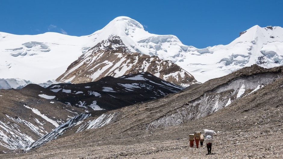
The trail follows along the side of Namata Khola and trekker follows upstream of the river, Khumjungar glacier. The numerous peaks highly dominate most of the landscape in the region. Yet trekker can see small bushes and meadows covered by snow before reaching the last section of Japanese Base camp. The environment and landscape sharply changes and trekker can notice glaciated ponds and rocky terrain once they are in Japanese Base Camp. Upon arrival, we check our climbing gear for the first time and try to explore around the ridges.
The climbing is not steep, as well the trekking hour is well balanced but walking in snowy glacier and rocky terrain can be hard and time consuming. The beautiful alpine landscape with view of Khumjungar Himal and Damodar Himal by the side is something trekker can apprciate. Trekker slightly change the direction towards left and bend right to reach the foothill of rocky cliff. Crossing the last section of glacier trekker are at High camp, that stretches up to Saribung pass.
The day is hard and long so trek start early in the morning. The first section of trekking path is in rocky glacier and soon follows the snowy section. Walking in between gorge of numerous peaks is thrilling itself. After climbing moderately steep, trekker is at the Saribung La pass (6050m). Turn right and climb about 280m to summit the Saribung peak 6328m. The peak is not technically hard, yet requires mountaineering equipment. After congratulation and picture session, we descend down and continue on other side of pass. We gradually leave snow and trek on rocky terrain to reach the Bhrikuti Base Camp.
Again from Bhrikuti base camp, we walk on difficult rocky path that leads to river. Trekker briefly climbs from river bed to reach Nagoru. The landscape and now becomes more friendly with abandoned village hut, temporary settlements and chorten. The valley looks very beautiful. After easy descend and ascend, crossing Phu Khola, we are in another highly isolated and remote Trans-Himalaya village Phu
Phu is an ideal place to take a break to explore hidden culture and tradition. Needless to say the community practices Buddhism with high value. The livelihood of people greatly depends upon unproductive agriculture, animal husbandry and traditional migration during winter for seasonal works on lower belt. Even tourism has not greatly contributed on cash inflow around this region. After short walk around the village we climb half an hour on the ridge of village to explore one of the renowned monastery Tashi Lhakhang Gompa .The landscape and surrounding peaks appear much brighter with Phu village seen at bottom more beautiful than ever you had seen before.
We cross Phu Khola and trek down through rocky and narrow canyons to reach Kyang. Kyang used to be a settlement for Khampa refugees during Khampa revolution in Tibet. A small juniper bushes in the region can be an opportunity to spot blue sheep. The trek descends further. We can see many abandon settlement and temporary houses. We gradually leave Trans-Himalaya landscape trekking down to Meta
Meta is great spot to capture beautiful view of Annapurna II, Lamjung Himal, KangGuru peak and Pisang peak. We steeply descend from Meta to reach Dharmashala. The trekking continues in thick sub-alpine forest. River canyons, small waterfalls in thick forest makes the trekking pleasant by the bank of Narphu khola. With small ups and downs our trekking joins to section of Annapurna round trekking at Koto.
There is possibility to drive in jeep due to road access and skip this section of trekking. However, this trekking is utterly beautiful and we avoid jeep road for most of the trekking section. Walking in temperate region of famous Annapurna Round trekking, one can experience beautiful hilly landscape, beautiful waterfalls, terraced farms by the bank of Marshyangdi river. More importantly, Tal located in the flat bank of river is amazing. You can enjoy the last trekking dinner with your guide and porter as a tribute to their hard work for making your trekking successful.
From Tal, we drive to Kathmandu. We drive in bumpy and gravelled off-road following Marshyangdi river to reach Besisahar. From Besisahar, we ride on black-topped road to reach Kathmandu. The zig zag and winding path to Kathmandu in crossing numerous small and big gorges is interesting and thrilling.
Although spending another day in Kathmandu is not mandatory. You deserve a rest day after such a lengthy trekking itinerary. Plus, this is contingency day in case. A rest day before boarding another lengthy international flight to home is a good idea.
Our office representative will be in your hotel 3 hour prior your flight time to drop you at Tribhuvan International Airport.
what's included?
- All Airport Transfers.
- Accommodation in Kathmandu and Pokhara with Bed and Breakfast.
- Tea House plus Camping Accommodation during Trekking & Climbing.
- 3 Meals in Trekking & Climbing with Breakfast Lunch & Dinner.
- Air and Road transportation as per the agreement made.
- All the necessary trekking staffs and porters for the Trekking & Climbing including 1 English speaking Trekking guide plus Climbing guide.
- All the paper works and documents required for the Trekking & Climbing including all the permits.
- Sleeping Bag.
- Salary, wages, food, accommodation and transportation of all the Nepalese staffs during Trekking & Climbing.
- Insurance of all the Nepalese staffs during Trekking & Climbing.
- First Aid Kit Bag(specially for Nepali staffs).
- All local taxes and fares.
What's not included?
- International Flight Fare.
- Visa fees.
- Travel Insurance (mandatory) of all the clients that needs to cover medical and Helicopter evacuation.
- Expenses of Personal nature (Laundry bill/Telephone bill/Equipment Charging Bill/Bar bill etc).
- Expenses incurred due to the unexpected situation (Strike/Natural calamities).
- Tip to Trekking & Climbing staffs.
- All Expenses not mentioned on Cost Includes section.
Frequently Asked Questions (FAQs) on Saribung peak Climbing
1. What is Saribung Peak Climbing?
The summit of Saribung Peak (6328m), trekking through Upper Mustang trekking region and climbing merely 280m from Saribung-La pass (6050m) is Saribung peak climbing.
2. Where is Saribung Peak (6328m)?
Saribung peak (6328m) lies at east-north of Upper Mustang trekking nearby Tibet boarder. The peak is a landmark between Upper Mustang and Nar Phu valley joint by the Saribung-La pass (6050m).
3. How can I go to Saribung Peak (6328m)?
Drive/ fly from Kathmandu to Pokhara. From Pokhara fly to Jomsom and trek through popular Upper Mustang trekking region and head further deep in snowline.
4. Why Saribung peak (6328m) is less than popular?
Saribung peak (6328m) climbing is less than popular. Although it is easy to summit the peak but the trekking itinerary is more challenging than to summit a peak. It remains less crowded during the peak season as well.
5. What kind of weather and temperature can I expect during trekking and climbing of Saribung peak (6470)?
The weather and temperature is highly unpredictable on mountain but generally during March April May (spring) and September October November (autumn) you can expect clear and warm day while evening will be cloudy and cold. The temperature is freezing in morning and evening in upper trekking region while lower region has tolerable cold.
6. What equipments or mountain gears do I need to climb Saribung peak (6328m)?
For trekking good pair of trekking boots, thermal wear, fleece jacket, Down jacket, light weight wind cheater, trekking pants and shorts, long sleeve and short sleeves T-shirts, rug sack or duffle bag, personal day bag, gloves, enough pair of socks, sunglasses, headlight, woolen beanie caps, water bottle, personal toiletries , gadgets and books depending on number of days .
For climbing you can hire most of the climbing equipments in Nepal if you don’t have. However you need Crampons, Ice axe, Tape slings, Harness, Ice Hammer, Ice screw, Karabiners, Ascender, Descender, Plastic climbing boots, Helmet, Snow bar, Rope.
7. I am amateur climber in Nepal, is this peak suitable for me?
The peak climbing itself is not difficult. However, assuming a trekker has some experience on snowline and remote trekking of Nepal, amateur trekker can easily summit the peak under our strict guidelines.
8. How flexible is Saribung peak (6470m) climbing itinerary?
The trekking and climbing itinerary for Saribung peak (6328m) is quite flexible. Instead of crossing Saribung-La pass and trekking to Phu valley, trekker and climber can return to Upper Mustang. Generally, during bad weather. Upon reaching Phu gaon trekker can continue to Kang-La pass and join to Ngawal. Plus, trekker can always skip jeep-road section to make itinerary short.
9. What if I finish trekking/climbing before schedule date?
We strongly advise you to follow the agreed final itinerary since we do not refund the trekking and climbing money. But somehow if you finish earlier we will always try our best to adjust the reservation of your accommodation but cannot be guaranteed.
10. What permits and documents do I need to climb Saribung peak (6328m)?
Saribung peak climbing permit issued by Tourism Department of Nepal, Special permit of Upper Mustang( free) and Special permit of Nar Phu( free) issued by Department of Immigration, Annapurna Conservation Area Permit fee (ACAP fee ) and TIMS card is required to trek and climb on this region.
11. What kind of food and Room can I expect during trekking and climbing?
Generally the food is fresh, tasty and can choose wide range of dishes from menu cooked by moderately professional cooks in tea houses while in base camp we assign our experienced cooking staffs. You will get comfortable and clean common twin bed room throughout the trekking. In base camp and where there are no tea-house we provide you good climbing tents.
12. What about drinking water during trekking/climbing?
Plastic water bottle are available in tea houses but it is highly recommended to avoid plastic bottles and use boil water instead, as well you may buy high grade water purification tablets on your home country or in Nepal.
13. What can I expect from Nepali staff?
Guide speaks good English so there will be no any problem for communication. While porter might or might not speak English but you can always speak with your guide to know more about the porter. We also assign experience climbing guide for successful accent of the peak. Nepalese trekking staffs are friendly and responsible with good sense of humor so you can open up for any conversation you like.
14. Do I need to buy Medical and evacuation Insurance?
Yes this is mandatory. You can purchase the insurance policy on your home country or we can assist you to buy the policy in Nepal.
15. Do I need special vaccination or Medical assessment before starting trekking /climbing?
Generally any kind of vaccination is not required. But, if you have long term health problem and under regular surveillance of your doctor it is recommended to consult your doctor. Though we provide basic medicines to our Nepalese staff but for you we advise to bring the general medicine from your own country.
16. Is there risk of Acute Mountain sickness (AMS)?
Yes there is always risk of Acute Mountain Sickness if you choose random trekking itineraries and do not follow the standard itinerary. But we always provide you the best and safe itineraries to avoid this deadly situation.
17. What should I do if I get Acute Mountain Sickness (AMS)?
We are always concerned with your safety. We suggest talking with your guide ASAP and descend to safe altitude. And if the situation doesn’t get any better we evacuate you immediately with helicopter and take you for further medical examination in designated hospitals and clinics.
18. What is the price of Saribung peak climbing?
We have provided you various options on our website to know approximate price regarding the trekking and climbing in Nepal; however there is always room to reach final agreement through private emails if there is any and we assure you there will be no any extra cost once we reach the agreement.
You are always welcome to send us private messages for the information that you could not find in this section regarding Saribung peak climbing. We will always provide the accurate information within 12 hours upon receiving your messages.
CANCELLATION
Free cancellation up to 60 days prior departure, after which the deposit becomes non-refundable.