22 days Chulu Far East with Mesokanto-La pass
Popular
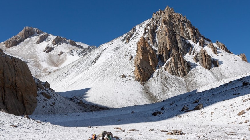
Chulu Far East with Mesokanto-La pass is one of the most thrilling itineraries in Annapurna trekking region. The Chulu peak has three summits Chulu East (6584m), Chulu West (6419m) and Chulu Far East ( 6059m). However, Chulu Far East is the easiest one to climb among all three peaks. In fact, trekker continues to other flanks upon successful summit of peak.
Certainly, Chulu Far East with Mesokanto-La pass trekking mostly covers the deep alpine section of Annapurna. Therefore, it is not on the top most priority of trekkers and climbers. In contrast, the view of beautiful numerous mountain ranges from the summit of the peak is flawless. Annapurna II, Annapurna III, Annapurna IV, Dhaulagiri ranges steal the shows. The interesting sight, down deep valley and glaciers from the peak are other talking points.
The first segment of Chulu Far East with Mesokanto-La pass itinerary follows the trail of famous Annapurna Round trekking. Starting at Marshyangdi valley, the itinerary advances in temperate zone with beautiful forest and villages of Himalaya. Sub-alpine villages Pisang and Nagwal keep entertaining trekker with rich culture and tradition of people. After summit of peak trekker descends to the biggest settlement of the region Manang. The itinerary skips busy route to Thorong-La pass, instead follows southwest path from Manang, to Tilicho lake (4919m).
Hostile Mesokanto-La pass(5340m) connects two famous valleys Marshyangdi valley and Kaligandaki valley. The pass remains closed for most of the year and requires proper equipment to cross. Moreover, we can use the same climbing equipment to cross the pass which is highly cost-effective. A reason to formulate innovative Chulu Far East with Mesokanto-La pass itinerary.
People follow Buddhism in places like Manang, Nagwal, Pisang. In the lower region of the itinerary trekker and climber can see people following Hinduism and Buddhism proportionally. Interestingly, leaving behind Manang, there are no huge settlements until trekker and climber reach Kaligandaki.
The Chulu Far East with Mesokanto-La pass is flexible as well in terms to start and end the trek. After Chulu Far East Climbing trekkers and climbers can trek/drive back or drive back to Syange from Manang. As well, they can continue trek to Kaligandaki valley crossing Thorong-La pass. The itinerary Chulu Far East with Mesokanto-La pass is also highly effective to combine with Narphu valley trekking as well.
Outline Itinerary
Day 1 International Arrival in Kathmandu(1300m)
Day 2 Sightseeing in Kathmandu(typically monuments listed on World Heritage sites) Permit preparation day, briefing by official executive, handing assignment to guide
Day 3 Drive from Kathmandu to Bhulbhule(850m)
Day 4 Trek from Bhulbhule to Syange(1315m)
Day 5 Trek from Syange to to Tal(1710m)
Day 6 Trek from Tal to Bagarchhap(2080m)
Day 7 Trek from Bagarchhap to Chame(2710m)
Day 8 Trek from Chame to Pisang(3300m)
Day 9 Trek from Pisang to Nagwal(36600m)
Day 10 Trek from Nagwal to Chulu Base Camp(3910m)
Day 11 Acclimatization day in Base Camp(4900m)
Day 12 Chulu Base Camp to High Camp (5335m)
Day 13 Summit Chulu Far East(6059m) and descend to Base Camp(3910m)
Day 14 Chulu Base Camp to Manang(3519m)
Day 15 Trek from Manang to Siri Kharka(4060m)
Day 16 Trek from Siri Kharka to Tilicho Base Camp(4140m)
Day 17 Trek from Tilicho Base Camp toTilicho Lake(4950m)
Day 18 Trek from Tilicho Lake to Yak Kharka(4200m) through Mesokanto-La (5340m)
Day 19 Trek from Yak Kharka to Jomsom(2715m)
Day 20 Fly from Jomsom to Pokhara(850m)
Day 21 Fly/Drive from Pokhara to Kathmandu
Day 22 International Departure
Note: This is a standard itinerary proposed for general trekkers which can be modified until then, that do not violate our business ethics and norms. We will always seek verification from our field experts before approving your itinerary.
Detailed Day to Day Itinerary
We will drive you straight to your hotel in private vehicle. We will give you short briefing about tomorrow sightseeing program and if you are the first time traveler in Nepal we will give information about restaurant, ATMs, money exchanger and other useful information until we meet for next day.
There are various major cultural historical and religious places around Kathmandu, Lalitpur and Bhaktapur for sightseeing. Pashupatinath,Bauddhanath,Swayambhunath,Bhaktapur Durbar Square,Kathmandu Durbar Square and Patan Durbar square are our top lists , since most of them are listed on UNESCO world heritage sites. Later in the evening we will arrange dinner with your trekking guide so you can know each other and talk about your trekking itineraries.
After your breakfast, we drive to Westside of Nepal on zigzag hilly road by the bank of Trishuli and head north following Marshyangdi river to reach Besisahar from Dumre.It takes 6 hr drive to reach Besisahar a well developed town from where most of the economic and administration works are handled. An hour drive from Besisahar on dusty and off-road takes you to Bhulbhule
Crossing a suspension bridge from Bhulbhule the path continues by the bank of Marshyangdi river with terraced paddy fields seen around. We may see the first glimpse of Mount Manaslu on horizon. Waterfalls accompanied by deciduous forest on hilly slopes of lower temperate region makes the trekking beautiful. We climb a steep hill to reach Bahundanda (literally hill of Brahmins) after crossing suspension bridge in Lampata. The trail again descends to reach Syange by the bank of Marshyangdi river that rejoins with jeep road.
The path is steep climb from Syange to Jagat. The trekking trail is alongside the dusty jeep roads which sometime get on your nerves but the dense forest with beautiful waterfalls and towering cliffs make the trekking wonderful. The path combines small ascends and descends to reach another settlement at Chamje, from where you will steep climb for an hour and cross suspension bridge to reach Tal a settlement by the bank of Marshyangdi River where we can see fraction of Tibetan culture and tradition inspired from Manang valley.
The trekking is fairly easy and gentle from Tal to Dharapani. The trekking continues by the bank of river with numerous waterfalls seen on the way with beautiful rock canyons. We will trek about three and half hours to reach Dharapani an intersection for Manaslu and Annapurna trekking. From Dharapani vegetations are mostly accompanied by Lower Temperate forest of chir pine ,maples,broken by few subalpine trees.
The trekking path from Bagarchhap to Danaque is flat and easy then we abandon jeep road to climb a steep up accompanied by rhododendron forest to reach a beautiful place Timang. Rocky cliffs adjacent to peaks and mountains really start to appear beautiful on horizon as you trek in pine forest. Lamjung Himal (6983m), Annapurna II (7937m) and Annapurna IV (7525m) are spotted which will continue to appear and disappear till the end of trekking. Chame is beautiful large settlement which is also an administrative headquarter of Manang district.
Leaving behind chortens and mani walls in Chame we trek on rocky and steep canyons for few hours in deep and narrow valley to reach Bhartang.We cross a suspension bridge and climb steep slope in between pine forest for about 2 hour and then the trail becomes more gentle and easy to reach Pisang ; village surrounded by Chulu and Pisang peak.The day becomes clearly interesting as trekking path from Upper temperate region enters to subalpine region with widening valley accompanied by shallow vegetation.
Normally there is straight lower route from Pisang to reach Manang but these days most of the trekkers take the upper trail through Gheru and Ngawal . Though you need to climb steep for an hour to reach Gheru it is highly recommended for the scenic views of Gangapurna,Pisang peak,AnnapurnaII AnnapurnaIII and Chulu peak on horizon and Marshyangdi valley at deep bottom. Due to poor rainfall and cold weather the subalpine vegetation seems dry and significantly different with sparse pine trees. The trekking path is easy with small up-downs in between pine trees to reach Nagwal.
From Nagwal we take upper trail that leads to another settlement Julu village.The trail is much more beautiful in open meadow and crop fields that gives unrestricted view of AnnapurnaIII and Pisang peak. Passing pine forest down the valley Julu village welcomes with numerous Chortens manis wall and paryer flags.Crossing the Julu Khola we head to Chulu Base Camp through rocky and isolated trail which takes approximately 5 hr and spend our night on tent.
In order to adopt our body with new environment, humidity, temperature and altitude it is highly important to acclimatize yourself. The climbing guide also provides the information on technical requirement to summit the peak and inspect the climbing equipments for final time. To amplify the acclimatization and as a practice session we climb few meters towards camp I (5335m) and return to spend the night at Base camp on the tent.
We start our climb first on grassy slope and then the path becomes rocky with few scattered snow and then gradually climb on snowy slope to reach High camp(5335m). We start our day as early as possible after breakfast to avoid the bad weather. As the climbing continues we see beautiful Annapurna ranges and Pisang peak dominating the whole valley. The landscape is very dangerous with numerous crevasses however we set camp on flat spot and spend night on tent.
The actual summit of the Chulu East starts as early as 2 am in the morning to avoid bad weather .Climbing through Chulu Far East ridge is comparatively easy however the pace is slow as you gain altitude. Upon summit you can see the magnificent Annapurna ranges including AnnapurnaI(8091m) AnnapurnaII(7937m) Annapurna south(7219m) at the south and Manaslu( 8163m) at the east with numerous peaks surrounding you. After quick photo session we descend down to base camp and spend the night on fixed tent.
We leave back the icy and rocky landscape behind and head to largest human settlement of the valley Manang. The green meadows and crop fields seems much more beautiful and lively than seen few days ago after spending long time on isolated landscape. Again the Annapurna ranges and Pisang peak is seen beautiful from Manang village. You can visit around Manang on your own to know few culture and tradition if you have any energy left.
We descend down the west of Manang valley and cross the river and again climb uphill to reach Khangsar which normally takes 2 hr from Manang. The Khangsar valley is really beautiful landscape with small juniper bushes broken by coniferous forest and some terraced crop fields while you can enjoy beautiful sight of Chulu peak on the horizon. We pass by an old Gompa to reach the lodge on Siri Kharka and spend a night.
The barren rocky and narrow slope is the worst and dangerous section due to unpredictable rock falling but the huge naturally eroded rock boulder looks really beautiful. After winding up the landslide area we reach Tilicho base camp from where we can see massif icy ridge that stretches from Khangsar peak to Tilicho Peak with huge glacier on the left side. We spend overnight either on lodge or tent depending upon the availability.
The path stretches further west north in middle of steep slope broken by grassy meadows and rocky pebbles. The Tilicho lake just lies on the foothill of Tilicho peak which remains frozen for the most of the year. You have enough time to explore around the lake and enjoy the spectacular and interesting landscape that surrounds the lake. We spend over night on our tent in eastern side of the lake which offers the beautiful view and is far safe than western or northern side.
First we climb the northern ridge of the Tilicho Lake commonly known as eastern pass(5360m) and start heading west. You can see beautiful Ngadi Chuli,Bouddha himal,AnnapurnaII , Dhaulagiri, Manaslu, Nilgiri and Gangapurna from the pass. Although there are three possible pass to reach down Jomsom we take the furthest west most common; Mesokanto North (5350m) pass that is distinctive by the rocky peak 5330m.The first 250m section of descend from the pass is very steep and sometime rope may require due to loose rock and slippery ice. The trekking fairly descends down the Jomsom valley and we set tent on open meadow field at 4200m.
The trekking continues to descend to Thini village through pasture land yet we can have magnificent view of Dhaulagiri,Tukuche, and Dhampus peak ahead.The small juniper bushes are seen along the way.A short walk from Thini village joins the main trekking trail on Jomsom where we spend our night on comfortable lodge.
In the morning after taking breakfast you will take a short flight from Jomsom to Pokhara. On reaching Pokhara you can relax on your own walking around lake side or can ask your guide to arrange short sightseeing trip around Pokhara
From Pokhara either you can take a short flight or take a private transportation to Kathmandu in accordance to the agreement we made before the start of trek.
Our office representative will be in your hotel 3 hour prior your flight time to drop you in Airport.
what's included?
- All Airport Transfers.
- Accommodation in Kathmandu & Pokhara with Bed and Breakfast.
- Tea House plus Camping Accommodation during Trekking & Climbing.
- 3 Meals in Trekking & Climbing with Breakfast Lunch & Dinner.
- Air and Road transportation as per the agreement made.
- All the necessary trekking staffs and porters for the Trekking & Climbing including 1 English speaking Trekking guide plus Climbing guide.
- All the paper works and documents required for the Trekking & Climbing including all the permits.
- Sleeping Bag.
- Salary, wages, food, accommodation and transportation of all the Nepalese staffs during Trekking & Climbing.
- Insurance of all the Nepalese staffs during Trekking & Climbing.
- First Aid Kit Bag(specially for Nepali staffs).
- All local taxes and fares.
What's not included?
- International Flight Fare.
- Visa fees.
- Travel Insurance (mandatory) of all the clients that needs to cover medical and Helicopter evacuation.
- Expenses of Personal nature (Laundry bill/Telephone bill/Equipment Charging Bill/Bar bill etc).
- Expenses incurred due to the unexpected situation (Strike/Natural calamities).
- Tip to Trekking & Climbing staffs.
- All Expenses not mentioned on Cost Includes section.
Frequently Asked Questions (FAQs) on Chulu Far East with Mesokanto-La pass
1. What is trekking peak /NMA peak climbing in Nepal?
27 Mountain peaks in between the altitude of 5844m and 6501m that can be climbed with additional 2-3 days (depending upon the technical requirement) in standard itinerary are known as trekking peaks or NMA peaks.
2. Where is Chulu Far East Peak (6059m)?
Chulu East(6584m) is one of the three flanks of peak Chulu that lies in between the mount Annapurna to the north and Mananag valley to the south on the famous Annapurna Round Trekking.
3. How can I go to Chulu Far East Peak climbing (6059m)?
Drive from Kathmandu to Bhulbhule and follow the Annapurna round trekking itinerary and continue to the base camp of Chulu from Ngawal.
4. Why Chulu Far East(6059m) is popular ?
In simple word it is comparatively easy to climb Chulu Far East (6059m) and need more moderate experiences and climbing techniques than other trekking peaks.
5. What kind of weather and temperature can I expect during trekking and climbing of Chulu Far East (6059m)?
The weather and temperature is highly unpredictable on mountain but generally during March April May (spring) and September October November (autumn) you can expect clear and warm day while evening will be cloudy and cold. The temperature is freezing in morning and evening in upper trekking region while lower region has tolerable cold.
6. What equipments or mountain gears do I need to climb Chulu Far East (6059m)?
For trekking good pair of trekking boots, thermal wear, fleece jacket, Down jacket, light weight wind cheater, trekking pants and shorts, long sleeve and short sleeves T-shirts, rug sack or duffle bag, personal day bag, gloves, enough pair of socks, sunglasses, headlight, woolen beanie caps, water bottle, personal toiletries , gadgets and books depending on number of days.
For climbing you can hire most of the climbing equipments in Nepal if you don’t have. However you need Crampons, Ice axe, Tape slings, Harness, Ice Hammer, Ice screw, Karabiners, Ascender, Descender, Plastic climbing boots, Helmet, Snow bar, Rope.
7. I am amateur climber in Nepal, is this peak suitable for me?
Yes we recommend Chulu Far East peak (6059m) for amateur trekkers and climbers along with Island peak in Everest trekking region.
8. How flexible is Chulu Far East (6059m) climbing itinerary?
Amateur trekkers and climbers are strictly suggested to follow the long standard itinerary to avoid Acute Mountain Sickness (AMS) but the itinerary is highly flexible for experience trekkers and climbers. You can cross Thorong-La pass or trek back same route to Besisahar after climbing the peak.
9. What if I finish trekking/climbing before schedule date?
We strongly advise you to follow the agreed final itinerary since we do not refund the trekking and climbing money, but somehow if you finish earlier we will always try our best to adjust the reservation of your accommodation and flight but cannot be guaranteed.
10. What permits and documents do I need to climb Chulu east(6059m)?
Chulu East climbing permit issued from NMA, Annapurna Conservation Area Permit (ACAP) and Trekking Information Management System (TIMS) card is required to trek and climb on this region.
11. What kind of food and Room can I expect during trekking and climbing?
Generally the food is fresh, tasty and can choose wide range of dishes from menu cooked by moderately professional cooks in tea houses while in base camp we assign our experienced cooking staffs. You will get comfortable and clean common twin bed room throughout trekking but Annapurna is extremely busy with countable tea houses so sometime it is really difficult to get good room in advance. In base camp we provide you good climbing tents.
12. What about drinking water during trekking/ climbing?
Plastic water bottle are available in tea houses but it is highly recommended to avoid plastic bottles and use boil water instead. As well you may buy high grade water purification tablets on your home country or in Nepal.
13. What can I expect from Nepali staff?
Guide speaks good English so there will be no any problem for communication while porter might or might not speak English but you can always speak with your guide to know more about the porter. We also assign experience climbing guide for successful accent of the peak. Nepalese trekking staffs are friendly and responsible with good sense of humor so you can open up for any conversation like.
14. Do I need to buy Medical and evacuation Insurance?
Yes this is mandatory. You can purchase the insurance policy on your home country or we can assist you to buy the policy in Nepal.
15. Do I need special vaccination or Medical assessment before starting trekking /climbing?
Generally any kind of vaccination is not required. But, if you have long term health problem and under regular surveillance of your doctor it is recommended to consult your doctor. Though we provide basic medicines to our Nepalese staff but for you we advise to bring the general medicine from your own country.
16. Is there risk of Acute Mountain sickness (AMS)?
Yes there is always risk of Acute Mountain Sickness if you choose random trekking itineraries and do not follow the standard itinerary. But we always provide you the best and safe itineraries to avoid this deadly situation.
17. What should I do if I get Acute Mountain Sickness (AMS)?
We are always concerned with your safety. We suggest talking with your guide ASAP and descend to safe altitude. And if the situation doesn’t get any better we evacuate you immediately with helicopter and take you for further medical examination in designated hospitals or clinics.
18. What is the price of Chulu Far East climbing?
We have provided you various options on our website homepage to know approximate price regarding the trekking and climbing in Nepal; however there is always room to reach final agreement through private emails if there is any and we assure you there will be no any extra cost once we reach the agreement.
You are always welcome to send us private messages for the information that you could not find in this section regarding Chulu Far East climbing. We will always provide the accurate information within 12 hours upon receiving your messages.
CANCELLATION
Free cancellation up to 60 days prior departure, after which the deposit becomes non-refundable.